Sunday, 4 September 2011

Deposition Landforms

Well the title might explain, Deposition Landforms are the features that occur when material form the Glacier is laid down. Whether its when the Glacier is still there or once it has retreated.

Rock Flour and Till

Rock Flour:- Rock sediment that has been grounded down to a fine powder. This usually flows out of a Glacier by meltwater streams.

 Till:- refers to an unsorted variety of sediment, clay, gravel and rocks that has been deposited by the Glacier.


Erratics

Unlike River deposits, Glacier deposits are angular and mixed up. Large rocks and boulders can be found on their own rather than in groups, but also they can be found located with other types and sizes of rock. These Erratics are usually a rock type that is uncommon in the area that they have been dumped, for example Erratics that have been found in Norfolk originated in Norway. This helps Glaciologists determine the direction of ice flow and monitor past ice movements across large areas.

http://www.geulogy.com/norfolk/merton-stone-norfolk.html

This image is of The Merton Stone, Norfolk. It is considered to be one of the largest Erratic in England.


Drumlins

Drumlins are elongated hills of Glacial deposits, most commonly Till. They can be up to 1km long and 500 metres wide, and often occurring in groups that are known as a swarm or a basket of eggs. These would have been the debris collected and accumulated under the Glacier, when the Glacier became overloaded with debris and sediment, it would have been deposited. Even though Glaciologists still disagree on exactly how Drumlins are created, they help to indicate the Glaciers movement. Shown in the below diagrams of a Drumlins cross section, one side is quite steep while the other end tapers to the ground, showing the direction of movement.

http://www.bbc.co.uk/schools/gcsebitesize/geography/glaciation/glacial_deplandrev1.shtml


Vale of Eden in the Lake District

I have also added an image of how a Drumlin looks in real life. This was also found on the BBC Bitesize website.

Moraines

When a Glacier melts or retreats, different types of rock are laid down that have been carried along by the Glacier. These deposit piles are called Moraines, there are different types of Moraines depending on where they were deposited.
  • Terminal Moraine:- Deposited at the furthest point that the Glacier reached
  • Lateral Moraine:- Material that is deposited along side the Glacier, on the side edges.
  • Medial Moriane:- Are found at the Junction of two seperate Glaciers that run along side each other.
  • Ground Moraines:- are disorganised piles of different types rocks that have no obvious features. These rocks may have been washed out by Glacier meltwater streams or left in situ when the Glacier melted.
Below is a diagram used on the BBC Bitesize website, to illustrate the different types of Moraines:-


http://www.bbc.co.uk/schools/gcsebitesize/geography/glaciation/glacial_deplandrev2.shtml


Thursday, 1 September 2011

Glacial Erosion Landforms


Glaciers make a huge impacts on landscapes, they exert vast amount of forces on the land. This causes dramatic changes caused by erosion.

Corries or Cirques

Corries are often the starting point of a Glacier. I'm adding a diagram here, so my explanation hopefully will make more sense. The diagram is from BBC Bitesize revision site

http://www.bbc.co.uk/schools/gcsebitesize/geography/glaciation/glacial_erosionrev1.shtml


Snow is captured in a hollow, and over a certain of amount of time this will turn into Glacier ice. As the ice is trapped in a hollow, it is unable to move downhill but gravity will still make the Glacier move. This circular motion within the ice is known as rotational slip and can cause the ice to pull away from the back wall and causing a crevasse.
Plucked debris from the back wall causes further erosion and which deepens the corrie and causes the hollow to get bigger and bigger. Some of this debris is deposited at the end of the Glacier and builds up a lip.
These processes create a rounded shaped hollow with a steep back wall, looks like a armchair. When the ice in a corrie melts, a lake is created within the hollow. This is known as a Tarn. An example of a Tarn is shown in this picture, its an image of Red Tarn on the eastern flank of Helvellyn in the Lake District.


Glacial Troughs

Glaciers cut out distinctive U-Shaped valleys  into the Landscape, this valleys are probably the most remembered landforms made by Glaciers, as it is a very common sight around the world. U-shape valleys are characterised by having a flat floor and very steep sides, This is caused by Glaciers moving through an already existing V-shaped valley caused by a river. The Glaciers force will erode the valley so it becomes wider, steeper, deeper and smooths down the sides. Below is an image of U- shape valleys, again found from the website bbc bitesize.
Hola Valley, Norway - photo courtesy of Jon Ragnarsson
Great Langdale Valley, Lake District
Like Rivers, Glaciers have tributaries. As the main Glacier erodes deeper into the valley, the tributary is left higher up the steep sides of a Glacier. These tributaries still cause a used U-shape valley ending with a water fall at the cliff face are called Hanging Valleys. Below is an image of a Hanging Valley
http://www.scalloway.org.uk/phyl12.htm
Unlike a river, which erodes softer rock to make an easier route, which causes interlocking spurs. As the Glacier has so much weight and pressure, the Glacier will erode the valley which causes Truncated Spurs. The sloping edges from a interlocking spurs are cut off, as the Glacier tends to move straighter.

These U-Shape Valleys flow all the way to the coastline, when the Glacier melts the valley becomes flooded with sea water. This is known as a Fjord, Fjord's are common along Norway, Alaska, New Zealand, Greenland and Scotland. Below is an impressive image of Fjords in Norway

Fjord Cruise on the Nærøyfjord
http://www.fjords.com/


Aretes and Pyramidal Peaks

Arete:- Is a knife edge ridge. It is formed when two Glaciers Corries run back to back or side by side. As each Glacier erodes either side of the the ridge, the ridge becomes steeper and the edge becomes narrower. E.g Striding Edge found in Helvellyn in the Lake District.

Pyramidal Peak:- Is formed with 3 or more corries and Aretes meet. The Glaciers have carved away at the top of a mountain, creating a sharp pointed summit. E.g Mont Blanc and Mount Everest.


Valley Floor Landforms

As the Glacier flows over land, it will meet harder and softer types of rock. Where the rock type is softer, the Glacier will erode a deeper trough than the harder, more resistant rock. When the Glacier melts, water will be left in this deeper troughs and form thin lakes called Ribbon Lakes. The areas of harder rock are called Rock Steps.
If a Glacier hits a particular resistant rock, it will flow over and around the rock. This leaves a smoothed rock mount, this comes in two types:-

Roches Moutonnee:- Often have steep, jagged faces created by plucking on the far side and a gradual incline which is smoothed by abrasion on the other side. Below is an illustration on how a Roches Moutonnee occurs

http://www.bbc.co.uk/schools/gcsebitesize/geography/glaciation/glacial_erosionrev4.shtml

Crag and Tail:- This is typically larger than a Roches Moutonnee. This works opposite to a Roches Moutonnee, as it hits the more resistant rock first and protects that rock behind it. Edinburgh is a perfect example of a Crag and Tail. Below is an illustration of how Crag and Tail occurs, again from the BBC Bitesize website.
http://www.bbc.co.uk/schools/gcsebitesize/geography/glaciation/glacial_erosionrev4.shtml

Monday, 29 August 2011

How does Glaciers affect the Landscape?

Glacial Processes


After studying What and Where Glaciers are, I am now going to look at how Glaciers shape and affect the landscape around them, this process is know as 'Glaciation'. With the weight of Glaciers and the gradual movement means that Glaciers can drastically change the land and cause new and unique landforms.
The Three processes by which glaciation affects the landscape is erosion, transportation and deposition.

Erosion

WEATHERING:- The most common form of erosion that Glacier's cause on the landscape if Freeze-thaw weathering. This is the action of glacial water getting into cracks,holes and joints within the rock, when it freezes it causes the rock to expand and widen. When the temperature heats up, it causes the water the melt and the rock contracts. Eventually this process cause pieces of rock to break off.

PLUCKING:- Plucking occurs when loosened fragments of stones and rocks, become frozen to the ice. When the Glacier moves, the stones are literally plucked from the ground, it leaves behind a jagged landscape.

ABRASION:- At school I always remembered this as the sand paper effect and in term of Glaciers its no different. Stones and rocks are embedded into the Glacier and as the Glacier moves the rocks rubbed against the bedrock and wears it down. It produces polished bedrock surfaces, that has scratches on.

There is more erosion processes that occur within Glaciation, however I have highlighted the most predominant processes.

On the BBC bitesize revision pages, I found this clip that I thought simply explained what a Glacier is but erosion processes as well. Please click on link below to watch.


Transportation

Glaciers are capable of moving large quantities of rock fragments and soil debris across huge distances. The distances all depends on material and the speed of movement of the Glacier. It is also important to put out here that Glaciers do not just move deposits from erosion, it may come from external sources such as:-
  • Rockfalls from weathering off other slopes
  • Avalanches
  • Wind-blown materials, such as ash and dust.


Deposition

The intense erosive actions produces large amount of sediment that can be transported by the movement of the Glacier. The deposition of sediment can be laid down miles away from their origins.
The collective name for all the sediments and debris deposited under all glacial conditions is Glacial Drift.
However Geographers have classified glacial sediment according to its mode of deposition:-

Fluvio-glacial - Sediments that were deposited by melting ice or by glacial streams, meltwater is abundant in warm based Glaciers.
Glacier Till - This is when debris is deposited directly by the Glacial, dropped 'in situ' by retreating ice. 

The below diagram shows the classifications of sediments in deposition.

http://cgz.e2bn.net/e2bn/leas/c99/schools/cgz/accounts/staff/rchambers/GeoBytes/AS%20A2/A2/Glaciation.Web/glacial_deposition.htm


Thursday, 11 August 2011

The When and The Why?

When did the Glaciers Occur?

The WHEN question is one of the 5Wquestions that I have set out for myself to answer. However doing my research. I have realised that this is a toughie, as there is no answer for this.

As previously stated Glaciers currently cover 10% of the world's land surface, however this Glacier Ice has been on the land surface for hundreds of years and it is only being sustained by annual precipitation.
Majority of the Glaciers that is currently around may have originated from the Last Ice Age, when Glaciers covered 32% of the land area. As the world has warmed up, the Ice has been melting. (this issue will be looked at in a later post), this is when Isostatic adjustment occurs. As the pressure is released from the shrinking Ice, the land is rising, as the pressure from the original Ice pushed the land surface down.


Why Do Glaciers Form

I have actually answered this question in my section of  'What is a Glacier', however I am going to go through it again. As repetition can sometimes be a goo thing.

When snow falls over hundred years and the climate of the area allows the snow to settle without melting or evaporating the snow. The pressure of the snow compresses together and forms a large Ice mass.

When Glacier Ice appears blue, it means that the ice is very dense. Years of compression makes the ice denser, as it pushes out any air pockets between the ice crystals. This dense ice does absorb all the colours of the spectrum but it primarily reflects Blue as there are very little air pockets.

Sunday, 17 July 2011

Types of Glaciers

I never realised there was so many types of Glaciers, I was naive to think that ice was just ice but the only difference was it's geography. However when you learn that Glaciers cover around 10% of the world's land surface, which means that every continent in the world has a Glacier, and they contain between 70-80% of the worlds fresh water supplies it doesn't seem so surprising.
I have used information from mainly http://www.nsidc.org/ and the http://www.geography-site.co.uk/ to try and condense the vast amount of information there is to fairly simple terms. These will allow students and me alike to understand and remember what type of glaciers there are. I will also be using images as well, which will hopefully show us what they look like.

ICE SHEETS:-
Ice sheets are only found in the Antarctica and Greenland. These sheets are huge Continental masses of glacial ice and snow that are larger than 50000 square kilometres long and up to 4200 meters dense in some areas. As these sheets are so dense, they cover over the whole terrain with the exception of the trans antarctic mountains

Below I have attached illustrates of both Greenland Ice sheet and Antarctica Ice sheet using images from the NASA photo gallery http://www.nasa.gov/

Greenland and surrounding Ice Shelves

Antarctica and its Ice Shelves


ICE SHELVES:-
Ice shelves occur when Ice sheets past the land surface and further extend out over the sea and float on the water. These Ice shelves surround most of the antarctic continent, which can be shown in the above image of Antarctica. It is at this area of the Glacier where calving can take place, calving is where ice breaks off at the end of a Glacier. At the Ice Shelves, the sea weakens the Glacier and can cause massive bits of Ice to break off, fell into the ocean and cause Icebergs.

ICE CAPS:-
Ice caps are smaller versions of Ice sheets, covering areas that are smaller than 50000 square kilometres. They are more commonly formed in polar and sub-polar regions that are relatively flat and high altitude. Similar to Ice sheets, Ice caps will cover the land completely but at certain parts of the year some bedrock can be seen. Below is an image of Vatnajokull Glacier, which is Iceland's biggest Glacier and the second biggest in Europe. Underneath this 8100 square kilometre Ice cap Glacier is seven hidden volcanoes, which most are active.

Vatnajokull Glacier, Iceland
http://iceland.vefur.is/iceland_nature/glaciers_in_iceland/vatnajokull.htm
ICE FIELDS:-
Ice fields are similar to Ice caps, however ice fields are effected by the topography of the land below. An Ice field may span over many mountain peaks or even a mountain range. Below is an image of Kalstenius Ice field, located on Ellesmere Island, Canada,  The Ice field produces multiple glaciers that flow into a larger valley glacier. (Royal Canadian Air Force photograph at the World Data Center for Glaciology, Boulder)

Kalstenius Icefield,
VALLEY GLACIERS
Last but not least is Valley Glaciers. These glaciers originate from Ice fields or Ice caps that spill downhill. As you can see in the above picture of the Ice field, Valley glaciers look 'much like giant tongues'  (http://www.nsidc.org/) that usually flow down existing steep V- shape valleys that have been previously eroded from rivers etc. The sheer pressure of these glaciers cause the V-shape valleys to erode and enlarge into flat bottomed U-shape valleys. These valleys are a common sight around the world today from past Glaciation periods. Valley Glaciers can be very long and flow far enough to reach the sea, this is then known as a Tidewater Glacier. Tidewater Glaciers are responsible for calving small icebergs that are not as big as Icebergs from an Ice Shelves but can still cause problems.
Below is a Picture that I took of Franz Joseph Glacier in New Zealand, that hopefully illustrates a Valley Glacier being constraint by steep Valley walls. Also from the http://www.nsidc.org/ gallery is a image of a tidewater Glacier.


Lamplugh Glacier, Alaska
Tidewater Glacier, that shows pieces of Ice debris in the Water
http://www.nsidc.org/

Franz Joseph

There are many other types of Glaciers which can be found on http://www.nsidc.org/ and http://www.geography-site.co.uk/ however I felt that these were the most common and more important. Also this post would be a mile long if I added all types of Glaciers.

Task for Students
Each Student would be assigned a different type of Glacier, as homework or during lesson time they would research the particular glacier. They would then present the Glacier type to the class. This will encourage self learning as well as allowing students a chance to present in front of their classmates

Monday, 11 July 2011

The Theory behind Glaciers

As a framework for researching Glaciers, I am going to use a tool that my teachers used during my education. It was very imaginatively named the 5W's, I felt that it was very beneficial for me in both learning and remembering topics. It allowed me to have the same framework for every topic covered and all I had to remember was the 5 W questions.
  1. What is it?
  2. Where is it/ where did it occur?
  3. When did it happen?
  4. Why did it happen?
  5. Who did it affect?
I know that some of the answers to the questions will over lap but the questions can be altered slightly to the specific topic that is being covered.


What is a Glacier?

Glaciers occur after many years of fallen snow in the same location, each new layer of snow compresses down on the previous layer to form large ice masses. Due to gravity and the sheer mass of these glaciers they flow like very slow rivers which cause changes in landscapes,which will be discussed later in another post. Also glaciers can vary in size, from relatively small glaciers to glaciers that are around hundred kilometres long.


Where do Glaciers occur?

As discussed in the previous post, using the map from the National Snow and Ice Date Center as a reference we discovered where Glaciers are distributed throughout the world. The locations that were highlighted support the theory of what conditions are needed for Glaciers to develop.                                  
For Glaciers to occur there needs to be a high snowfall in the winter and cool temperatures during the summer. This allows the snow to settle on the ground for the compression to take place over many years. The cool temperatures mean that the snowfall will neither melt, evaporate or allow 'calving' to take place (this will be explained in another section of my blog).
For the growth of Glaciers the amount of precipitation is very important. Even where the temperatures in an area may be very low throughout the year, if the area also has low precipitation levels the growth of the Glacier will be slow.


The next installment will look at the types of Glaciers and why Glaciers are around ...


Sunday, 3 July 2011

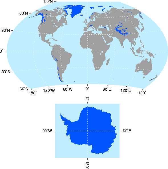
World Map of Glacier and Ice Distribution

I wanted to add a map showing glaciers and ice distribution across the globe.
This map was found on the National Snow and Ice Data Center http://www.nsidc.org/.

I think that a lot of people and children, me included, have their learning and understanding on topics greatly increased using visual aids. Knowing where glaciers are in the world as well as what they look like will help them to grasp the theoretical concepts quicker (hopefully).
This map allows the viewer to understand that glaciers are massive landforms that cover a large areas of our earth surface. Presently glaciers and ice are situated on high altitudes such as the Alps, Himalayas and the Andes mountain ranges as well as predominately being higher than 60 degrees north of the equator and lower than 60 degrees south of the equator.